Demo sites
Lodz
The upper Lodka River

The City of Łódź is the third biggest city of Poland. In 1820 it has been established an industrial settlement due to its rich resources required for textile industry, namely dense forests, abundance of water (22 small and fast flowing rivers), and mostly state ownership of the land. At that time it was inhabited by 800 people. Only ten years later this number increased to 4 thousands, to reach 40 thousands in 1865 and half million by 1914.
Such rapid development towards a textile industry capital of Central and Eastern Europe, supplying markets in Russia and Asia, had strong negative impact on its natural resources and quality of life. Soon industrial pollution contaminated rivers and the only source of potable water became wells. Those also got contaminated with time. The only choice to protect people health and to reduce flooding risk to infrastructure was channelization of rivers. They have been merged with underground stormwater and sewage systems.
According to climate change scenarios, Łódź is located in the drought zone characterizing with higher frequency of spring and summer rain shortages and simultaneous increase of average spring and autumn temperatures. Climate change, urbanization, and water overuse in the past caused serious drop of groundwater level and destroyed source areas of city’s rivers. Many of them, including the Łódka river, are currently supplied mostly by stormwater overflows, what creates both water quality and hydraulic problems. In order to restore water cycle in the city, the stormwater and sewage systems need to be separated from rivers, while rainwater has to be stored and purified in the landscape. Thus the regulatory ecosystem services should be strengthen across the City. Accomplished in 2018, climate adaptation plans foresaw increasing role of Nature-Based Solutions, especially rain gardens, detention and retension basins and reservoirs in water management.
Ecohydrology was definied in a frame of the UNESCO International Hydrological Programme (IHP) as a transdisciplinary and applied science. Its foundation is understanding of a mutual relationships between hydrological and biological processes at the catchment scale. Already in 1997 Ecohydrology postulated using ecosystem properties to achieve water quality improvement, biodiversity enhancement and sustainable development. In this sense the concept was far ahead of its times raising an issue of nature-based solutions as a cost-efficient approach.
The Ecohydrology approach is based upon the assumption that the sustainable water resources management can be achieved by:
- restoring and maintaining evolutionarily established processes of water and nutrient circulation and energy flows at a catchment scale;
- enhancing of carrying capacity of catchment against human impact based on evolutionarily established resistance and resilience of its ecosystems to stress;
- using ecosystem properties as water management tools.
The approach was firstly introduced to the City of Lodz as a big scale, integrated thinking, in 2005, under the umbrella of FP6 project SWITCH: Managing water for the city of the future (http://www.switchurbanwater.eu). Then the stakeholders of the city forming Learning Alliance group formulated the strategy for Łódź 2038: Łódź uses its water wisely. ATENAS builds upon the same approach and collaborates with LA, moving activities from river valleys to the urban fabrics.
The Blue-Green Network (Zalewski et al. 2012) is a project embedded in the context of the Łódź natural system that integrates and extends previous planning documents concerning the green architecture in city. The project draws on the fact that the city is located between the Vistula and Odra watersheds and there are many small streams within its boundaries. The system of rivers and adjacent green areas as well as green ring around Łódź creates the basis for a functional, economical, logical and the user-friendly arrangement of urban space that provides multiple benefits to residents. These benefits include: enhanced stormwater retention and purification, the prevention of flooding and drought; improved microclimate, air quality and decreased risk of allergy and asthma; improved resistance and reduced maintenance costs of urban greenery; space for recreation and green public transport; increased flexibility of the city in adapting to global climate change; improved attrac-tiveness of urban space to residents and investors.
In order to protect, sustain and develop BGN for efficient water, biodiversity and climate regulation, it needs to be completed with green backyards, frontyards, squares and green streets, which increase integrity of the network securing flow of ecosystem services from delivery to recipient sites. ATENAS, through water flow modelling, analysis of administrative, legal and societal barriers and needs will enable filling the gaps in BGN system.
ATENAS approached a number of city actors, starting from scientists and decision makers, through activists and local leaders, marginalized communities, and ending with investors, to gather the opinions about existing blue-green infrastructure, possibilities to enhance its potential and area, and range of opportunities it may create. We mapped communities of both knowledge and interest, identifying the synergies. ATENAS has also identify spaces where community building can come together with participatory actions towards strengthening ecohydrological services with implemented NBS.
The actions will concentrate on the upper catchment of the Łódka River, being an icon of the city and a symbol of its industrial past.
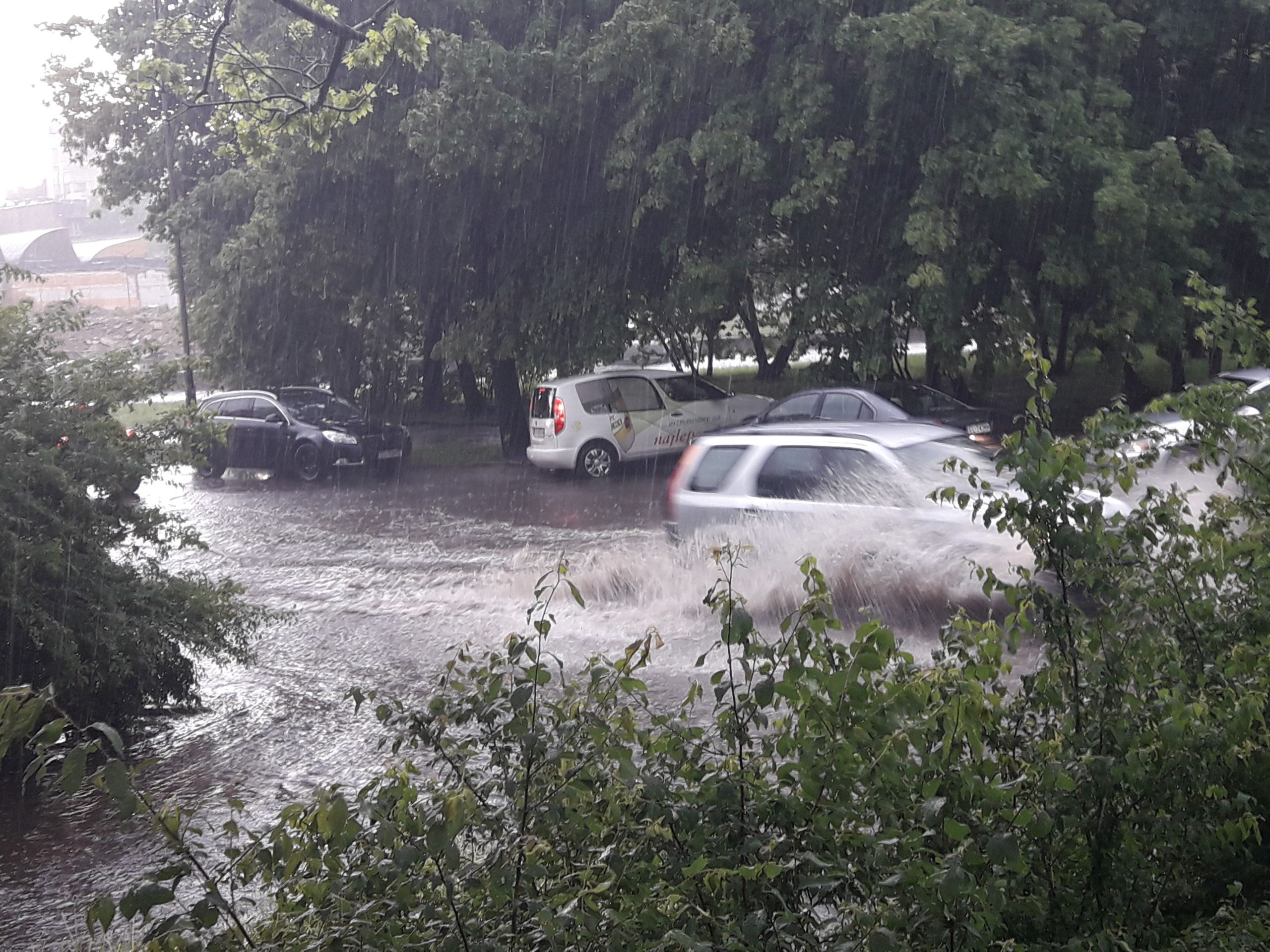
Runoff accumulation in the street after a cloudburst (photo K.Krauze)

Blue-Green Network (City Masterplan 2010)
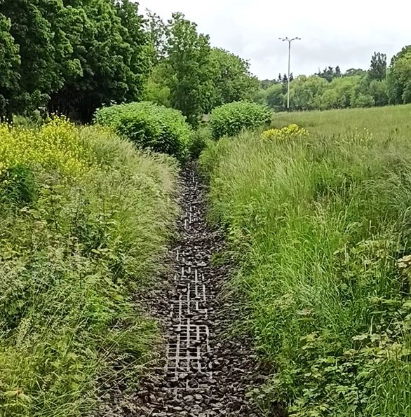
The empty channel of the Łódka River
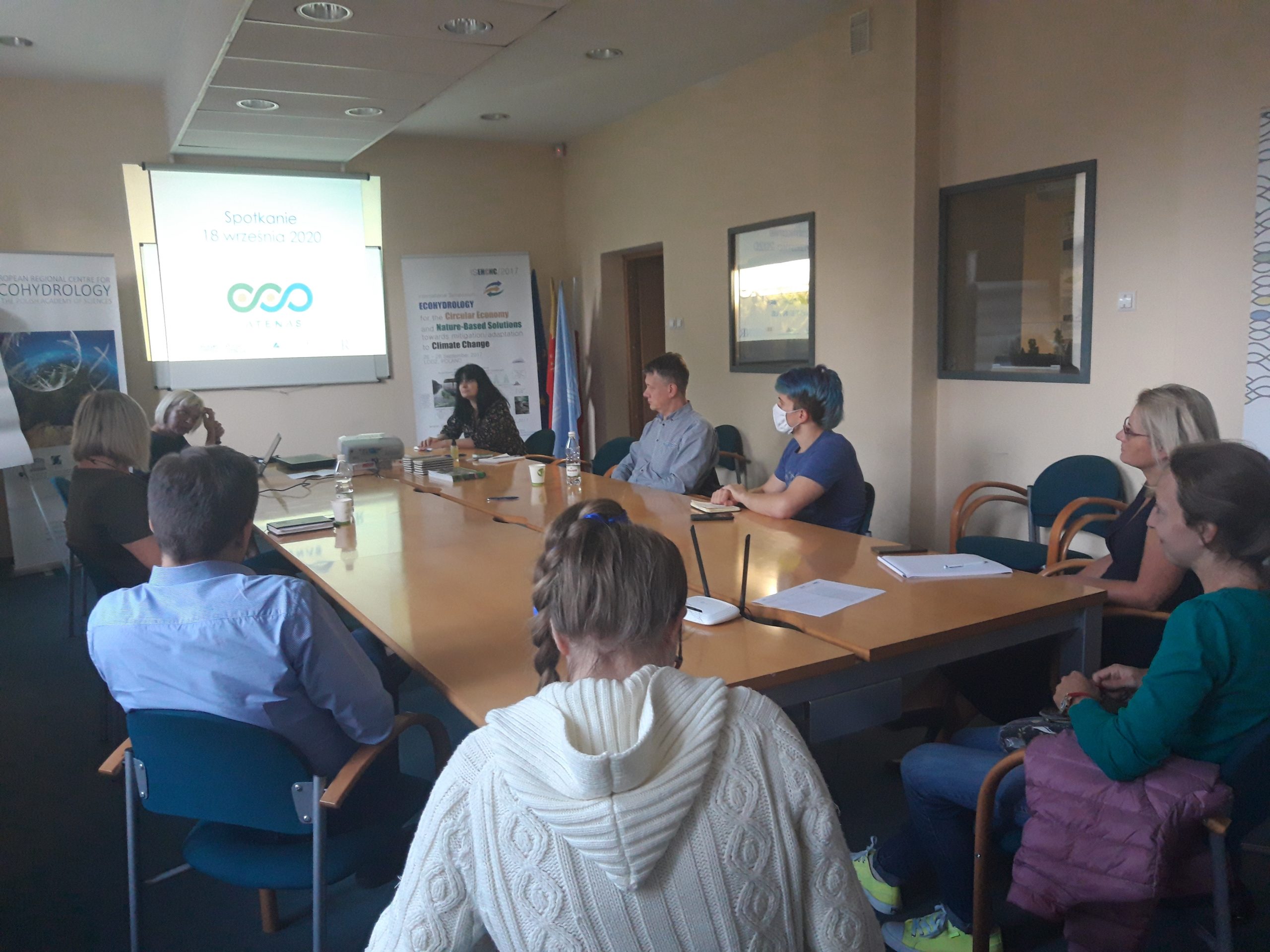
Meeting with local leaders
Helsinki
Vantaa

In Finland, AteNas analyzes opportunities and barriers of recently implemented nature-based stormwater management systems in Helsinki metropolitan region and promotes collaboration and co-design action with city planners to enhance implementation of NBS in urban planning. We have two developing suburbians as case areas: Kivistö in the city of Vantaa and Malmi in the city of Helsinki.
We have adopted co-design approaches and multicriteria decision analysis (MDCA) in assessing stormwater management scenarios for the stormwater park in Kivistö.
In Malmi, Atenas provides hydraulic modelling (SWMM) to assess benefits and limitations of different stormwater management scenarios (grey, green roofs, water retention structures, etc.) as a part of infillment of the suburbia Malmi. We will also test and develop a novel method of regional green area factor for public spaces with supporting help from local private consulting company (WSP) in Malmi.
In addition, we are also conducting internet-based public survey about perceived values of water element is cities targeted to citizens in Kivistö and Malmi.
Making the multiple benefits of nature-based solutions more visible has been considered important to accelerate their implementation in the urban environment. Previous research has highlighted many obstacles such as knowledge gap, uncertainty regarding implementation process and effectiveness of the solutions, inadequate financial resources, institutional fragmentation and sectoral silos. Therefore, developing co-design tools to enhance knowledge exchange and open dialogue between different sectoral actors that can surpass these challenges are very important to successfully implement and upscale NBS.
In Kivistö which is suburbia of the City of Vantaa, new area for 45 000 residents is under planning. Atenas uses co-design approaches and value-focused thinking based multicriteria analysis in identifying objectives for planning, developing two stormwater management alternatives meeting these objectives and comparing the alternatives in Kivistö. The aim of the workshops is to find the answers e.g. to the following questions: Which objectives are important in the target area and how the options considered differ in these factors. The project also aims to produce a ‘tool’ that the City of Vantaa can use in the future to reconcile different interests in urban planning, and to make recommendations for the use of the multi-criteria approach as part of urban planning.
The Atenas project aims to promote the use of nature-based solutions by developing tools and methods to support their impact assessment and implementation. In the case study of Malmi, we want to find out how the impact of nature-based solutions on water management and other benefits could be determined in a sufficiently general way and with a reasonable amount of work to serve the vision in urban planning.
The project aims to answer following questions: How can the regional green factor be used to produce future land use scenarios? How do the different scenarios correspond to the goals of urban planning and water management in the center of Malmi?
The City of Vantaa is developing an attractive and safe living environment. To learn more about it you can visit the website of the city: https://www.vantaa.fi/housing_and_environment/urban_planning_and_land_use/the_suburbs_and_the_districts/kivisto
Malmi is foreseen to grow into the new centre of north-eastern Helsinki. To learn more about its planning and development please visit the website: https://www.uuttahelsinkia.fi/en/malmi.

The framework for MCDA in Kivistö

Stormwater NBS in Kivistö (photo J. Torkko)

The final stormwater reservoir in Kivistö (photo S. Koivisto)
Rainwater reservoir in Malmi (K. Vierikko)
Lyon
Yzeron river

The Yzeron catchment (150 km2) is located to the south-west of Lyon city, France. It forms part of the Observatoire de Terrain en Hydrologie Urbaine (OTHU, 2011) long term observatory. It is representative of French periurban areas and is characterised by a marked topography. A fast progression of urbanisation is observed since the eighties.
The area is prone to sharp Mediterranean-type flood events due to its steep topography in the upstream part and limited soil water storage capacity overall. The water coming from combined sewer overflow devices is rich of sediments and pollutions, causing quality problems in the rivers.
The porous ramp is an application of the principles of ecohydrology (http://ecohydrology-ihp.org/demosites/ ) which uses the interaction between water flows and biocenoses. The device makes it possible to amplify this dual relationship while taking advantage of the seasonal nature of the watercourse, the sandy nature of its substrate and its hydrological disturbance by urban discharges during rainy weather.
The principle is to trap and adsorb the pollution, carried by the river flow increase during summer storm events. Porous ramps are equipped in their upstream part with a permeable geotextile to block the natural sand transport which accumulate in the upstream. The high porosity of the porous ramp, composed of coarse pebbles, allows water to flow easily through the sand bar. The processes of biodegradation by oxidation and reduction are conditioned by the flow rate of the watercourse. The morphological shaping of the river bed amplifies the natural self-purification capacity in a sector that is heavily polluted by urban discharges during rainy weather.
Given the experience accumulated from a field pilot over several years of experiment and considering the proof of concept was done, we decided to test it at a demonstration level. The Yzeron river basin syndicate, in accordance with the ATENAS project, accepted to support this first implemention after having discuss its design and suitable location with the local fishing association.”
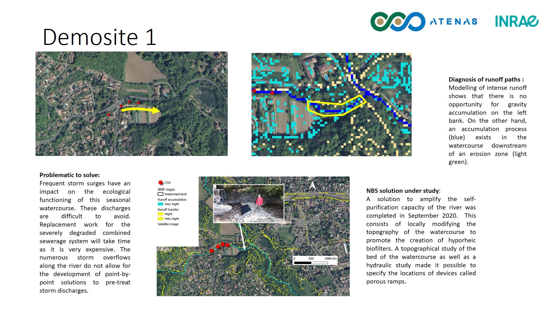
Frequent storm surges have an impact on the ecological functioning of this seasonal watercourse. These discharges are difficult to avoid. Replacement work for the severely degraded combined sewerage system will take time as it is very expensive. The numerous storm overflows along the river do not allow for the development of point-by-point solutions to pre-treat storm discharges.
NBS solution under study:
A solution to amplify the self-purification capacity of the river was completed in September 2020. This consists of locally modifying the topography of the watercourse to promote the creation of hyporheic biofilters. A topographical study of the bed of the watercourse as well as a hydraulic study made it possible to specify the locations of devices called porous ramps.
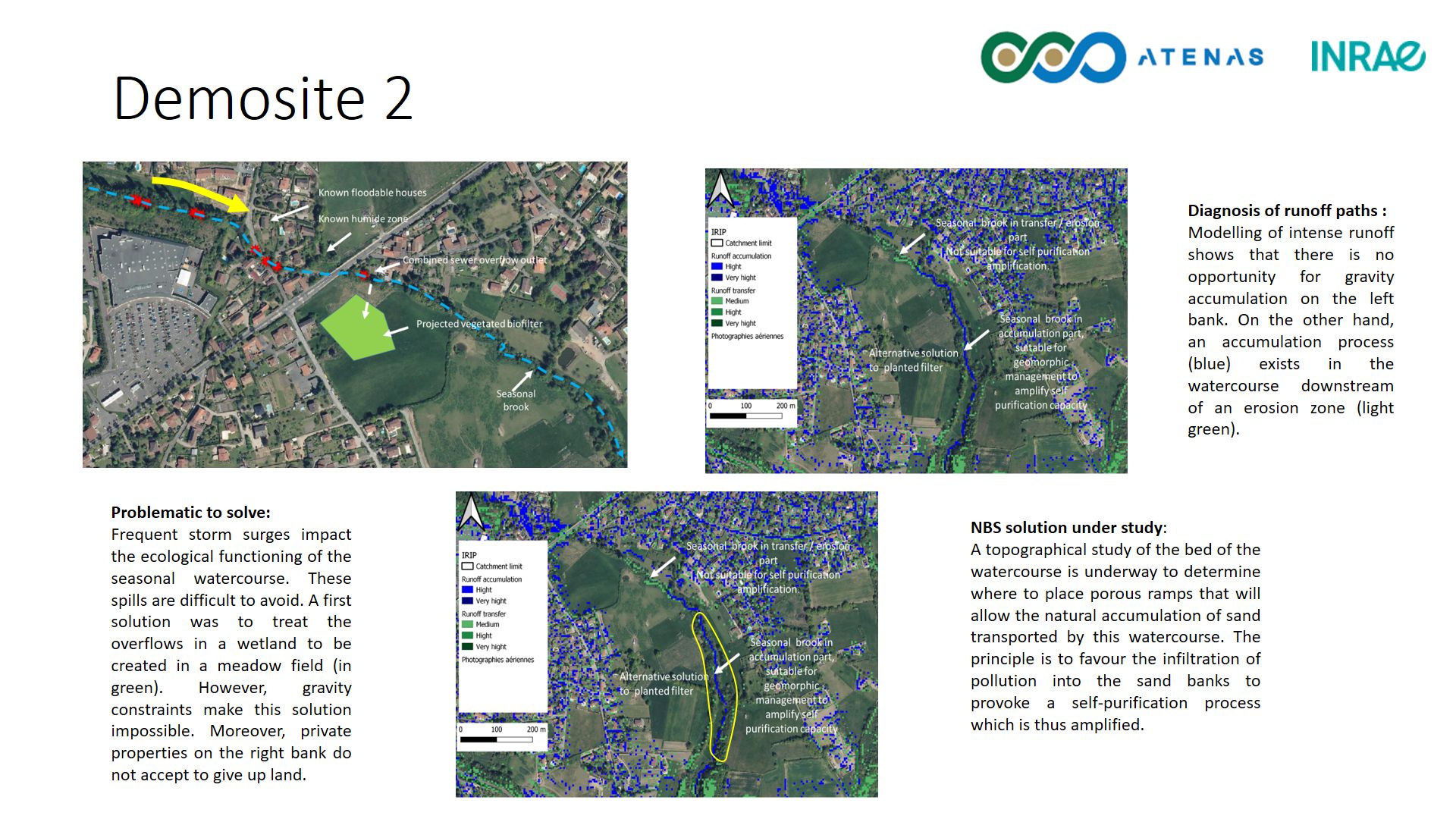
Frequent storm surges impact the ecological functioning of the seasonal watercourse. These spills are difficult to avoid. A first solution was to treat the overflows in a wetland to be created in a meadow field (in green). However, gravity constraints make this solution impossible. Moreover, private properties on the right bank do not accept to give up land.
NBS solution under study:
A topographical study of the bed of the watercourse is underway to determine where to place porous ramps that will allow the natural accumulation of sand transported by this watercourse. The principle is to favour the infiltration of pollution into the sand banks to provoke a self-purification process which is thus amplified.
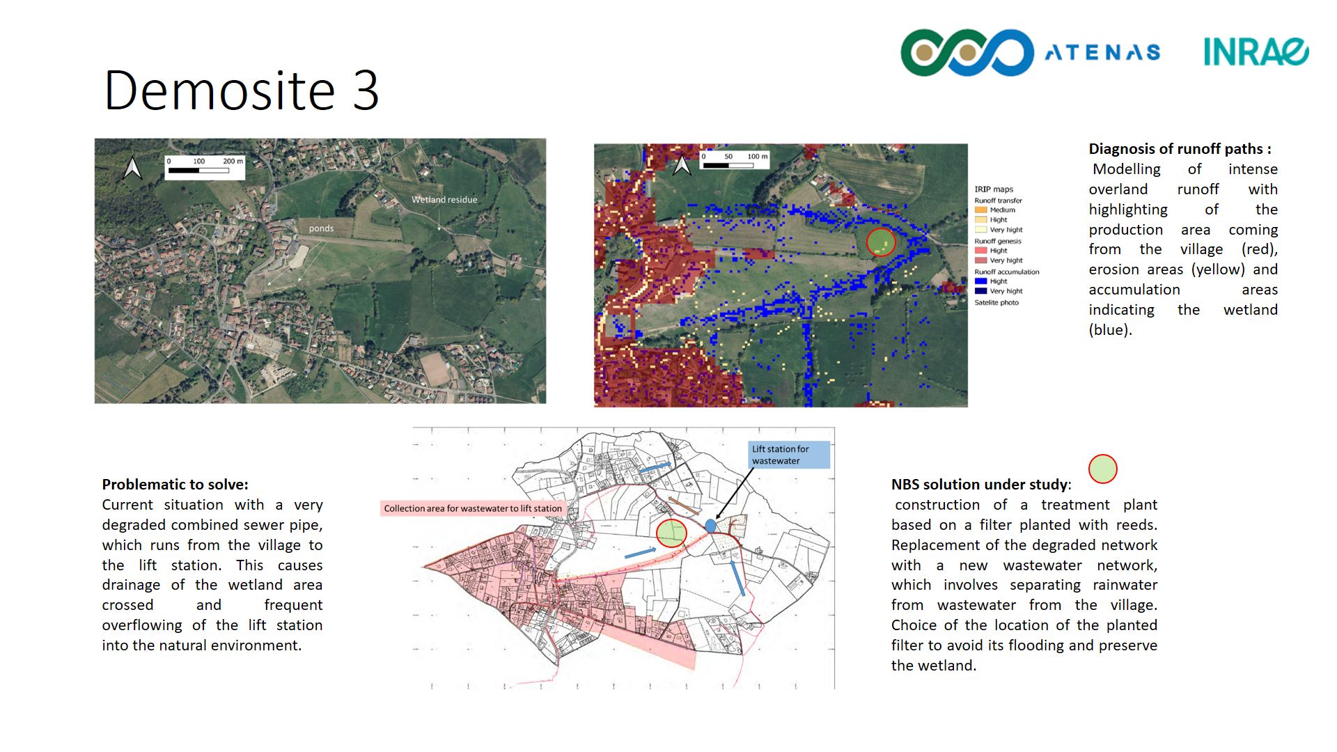
Current situation with a very degraded combined sewer pipe, which runs from the village to the lift station. This causes drainage of the wetland area crossed and frequent overflowing of the lift station into the natural environment.
NBS solution under study
A construction of a treatment plant based on a filter planted with reeds. Replacement of the degraded network with a new wastewater network, which involves separating rainwater from wastewater from the village. Choice of the location of the planted filter to avoid its flooding and preserve the wetland.
Lyon demosite 1
Lyon demosite 2